Utility Detection
Geo Dynamics Arabia provides specialized utility detection & surveys using various types of Ground Penetrating Radars (GPR). Our Geo-physicists will develop and perform the required surveys based on the information gathered from our client and site observations.
All Services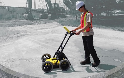
GDA provides specialized utility detection & surveys using various types of Ground Penetrating Radars (GPR). Our Geophysics will develop and perform the required surveys based on the information gathered from our client and site observations. Each project is considered as a special case.
The utility detection Surveys can map the sub-surface environment for a wide range of features, to inform invasive investigations, prior to excavating, tunneling and drilling taking place.Our Underground Mapping helps Design the Risk out of projects to:
- Decrease risk of harm & injury to persons
- Decrease risk of damaging buried infrastructure
- Minimize disruption & inconvenience to general public
- Minimize project delays & reduce costs
- Understand service diversion needs
- Pin-point invasive investigation requirements
- Negate unnecessary excavations
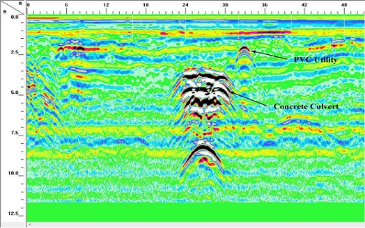
A full GDA Underground Mapping Survey can locate:
- Buried Services and Utilities including Water, Power, Gas, Telecommunications, Fiber Optics, Drainage and other linear targets.
- Voiding such as evidence of erosion, cellars, badger setts, well/mine shafts and tunnels.
- Sub-surface features such as old building lines, foundations, buried concrete, tanks and other hazards.
- Disturbed and saturated ground (which may result from water or oil leaks).
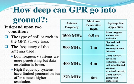
- Depth to Bedrock, the water table or ground layers.
Drawing results are provided in AutoCAD and PDF formats, displayed, primarily in 2D plan view format with 3D information, designed to be read by anybody from Designers to Ground workers.
View Our Works